
Geography & Climate
Geography & Climate
A volcanic island, four coasts, a coral reef and one of the most remarkable locations on earth.
Location
20°17'S 57°33'E, Indian Ocean
Area
2,040 km²
Dimensions
61km × 47km
Coastline
~330 km
Highest Point
Piton de la Petite Rivière Noire, 828m
Origin
Volcanic, ~8 million years old
Nearest mainland
Madagascar, ~2,000 km west
Time zone
UTC+4 (no daylight saving)
Location
Where in the World
Mauritius lies at 20°17'S 57°33'E in the south-western Indian Ocean. It is part of the Mascarene Islands, a chain that includes Réunion (220km to the west) and Rodrigues (560km to the east). The nearest mainland is Madagascar, approximately 2,000km to the west. Africa's east coast (Mozambique) is about 2,400km away.
Flight times give a sense of its position: roughly 4 hours from South Africa, 5 hours from Dubai, 9 hours from India, and 11 hours from London. It sits in the same time zone as Dubai (UTC+4) and maintains that time year-round — no daylight saving adjustment.
The island's position — southeast trade wind belt, tropical but tempered by the ocean, sheltered on the north and west, exposed on the south and east — determines virtually everything about its climate, its coast types, and the distribution of tourism infrastructure.
Geology
Volcanic Origin
The mountain ranges are remnants of the ancient volcanic crater walls
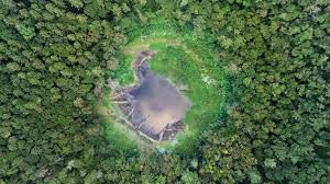
Mauritius is the product of the Réunion hotspot — a stationary plume of superheated mantle material that punches through the moving tectonic plate, creating a chain of volcanic islands. The same hotspot is under Réunion today (two active volcanoes); it was under Mauritius 8–9 million years ago. What remains is a deeply eroded ancient shield volcano.
In 2017, scientists found evidence of an ancient “lost continent” — Mauritia — beneath Mauritius. Zircon crystals far older than the volcanic island (3 billion years) were found in lava flows, suggesting a fragment of ancient continental crust lies buried under the island.

Landscape
The volcanic interior — plateau, gorges and mountain ranges
Landscape
Topography

600–700m
Central Plateau
The flat upland heart of the island. Cooler and wetter than the coast. Cities of Curepipe, Quatre Bornes, Vacoas and Rose Hill. Major agricultural area. Often shrouded in cloud — notoriously misty and cool by Mauritian standards.

Up to 828m
Mountain Ranges
Moka Range (centre-east), Corps de Garde (west), Bambous Mountains (east), Mahébourg Hills (south-east). The mountains are remnants of the volcanic crater walls — sharp, dramatic ridges visible from across the island.

300–600m
Black River Gorges
Deep gorges cut through the south-west by rivers. The main valley is spectacular — steep forested sides dropping to the west coast. National Park covers 6,574ha. The largest remaining tract of native forest. Best hiking on the island.
Coastline
The Four Coasts

Grand Baie, Trou aux Biches, Pereybere, Cap Malheureux
Sheltered from the south-east trade winds by the island's bulk. Consistently warm and dry. Calm lagoon protected by the outer reef. The most tourist-dense coast. Best snorkelling at Trou aux Biches. Departure point for boat trips to offshore islands.

Belle Mare, Trou d'Eau Douce, Île aux Cerfs
Takes the full force of the constant south-east trade winds. Sea is rougher, especially in winter (May–October). The lagoon is wider here — Île aux Cerfs is set in a spectacular shallow bay. Long, deserted white sand beaches. Popular with kiteboarders. Flatter coastal plain than the west.

Mahébourg, Blue Bay, Bel Ombre, Gris Gris
Basalt cliffs, dramatic wave action, and a more rugged character than the tourist north. Rochester Falls. The Gris Gris cliffs — the most dramatic scenery on the island, where waves crash directly against volcanic rock. Blue Bay is the exception — the finest snorkelling in Mauritius. Less developed, more authentic.

Flic en Flac, Tamarin, Le Morne, La Gaulette
Famous for sunsets over the Indian Ocean. Sheltered and calm. Le Morne peninsula is a UNESCO World Heritage Site. Spinner dolphin pods live permanently in Tamarin Bay. Popular with expats and families. Good diving off Flic en Flac. The Black River area has good restaurants and a growing community of long-term residents.
Island Group
Outlying Islands

560 km east
Rodrigues
Has its own Regional Assembly. Population ~43,000. Distinct, quieter culture. Excellent diving and kitesurfing. Reached by Air Mauritius or catamaran (3 days). A destination in its own right.

1,000 km north
Agalega
Two small islands with a population of ~300. Very remote. Coconut farming. Recently built airstrip (Indian-funded, military significance). Rarely visited.

400 km north-east
St Brandon / Cargados Carajos
A group of low-lying sand cays and reefs. No permanent settlement. Home to seasonal fishermen. Exceptional diving and fishing — almost inaccessible.

~2,000 km north
Chagos / BIOT
The British Indian Ocean Territory, including the US military base Diego Garcia. Detached from Mauritius by Britain in 1965. Sovereignty claimed by Mauritius — an active and unresolved international dispute.
Weather
Climate

Hot and humid. Temperatures 28–35°C on the coast. The central plateau is cooler by 5–7°C.
Cyclone season runs November to April — average 2–3 cyclones pass within 500km per season, direct hits rare.
The north and west are in rain shadow; the east and centre receive the heaviest rain.
Sea temperature 27–29°C. Ideal for marine life activity. Water visibility can be reduced after heavy rain.

Dry season. Cooler temperatures 20–26°C on the coast. Ideal for outdoor activities.
Constant south-east trade winds. The east coast is rougher; the north and west are calm.
Very low humidity. Clear skies. UV index remains very high (8–10) — SPF 50+ essential year-round.
Best time to visit Mauritius — May to November offers the most reliable weather.
Up to 4,000mm/year. One of the wettest areas in Africa. Curepipe is notoriously grey and misty. Dense cloud cover common on the plateau.
1,500–2,500mm/year. The trade winds hit the east first, depositing rain before they reach the rest of the island. Rougher seas in winter.
800–1,200mm/year. Rain shadow from the central mountains. Driest, sunniest areas of the island. Ideal for beach tourism year-round.

Cyclone Season
Cyclone season runs from November to April. On average, 2–3 cyclones or tropical storms pass within 500km of Mauritius per season. Direct hits are rare — the most significant in recent decades was Hollanda in 1994. The last major disaster cyclone was Carol in 1960 (42 deaths), which prompted the infrastructure improvements that have made modern Mauritius largely resilient.
The Mauritius Meteorological Services issues a warning system from Class 1 to Class 4. Class 1 is a distant watch; Class 4 means a direct hit is imminent. Schools close at Class 2. At Class 3 and above, residents secure property, stock water and food, and stay indoors.
Modern concrete buildings (standard for all residential and commercial construction) are built to withstand Class 3 cyclone winds. Deaths from cyclones have been extremely rare since the 1960s. If visiting in cyclone season (Nov–Apr), check the Met Service website and follow official guidance if a warning is issued.
Explore More